
This page presents a summary of the results of work at Morham Castle. You can read the report here.
Introduction
The site of Morham Castle, East Lothian, is marked on the 1st Edition Ordnance Survey map (below) though no trace is visible on the ground today. The site lies in an arable field bounded by Morham Burn on its north and east, and bordered by the road to Morham Church on its west. Morham Kirk lies to the north of the castle site, along the burn. The kirk has roots back to the early medieval, with a 9th century carved cross-slab being incorporated into the church wall when it was rebuilt in the 18th century.
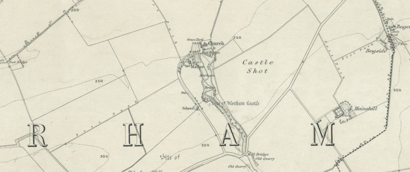
Though the castle was ruinous or entirely removed by the time the First Edition OS map was published in the late 19th century, it was retained in living memory towards the end of the 18th century: contemporary documentary sources indicate that the castle was once a large and extensive structure (OSA 1792), the residence of the Lord of the Manor (OS Name Book 1853; 44/4). The New Statistical Account gives a short rendition of the ownership of the lands of Morham from the Malherbe family in the 12th century, up to its sale in 1830, mentioning prominent names such as the Giffords, the Hays, and the Earls of Bothwell (NSA 1845; 263). You can read in more detail about the families associated with the castle, and their fascinating stories, in the full report.
Geophysical survey was carried out by Edinburgh Archaeological Field Society on behalf of East Lothian Council at the proposal of the local community in Morham in 2012/2013. This survey revealed several potential features for investigation, which formed the targets for our excavations.
The Excavations
Excavations in August 2019 aimed to determine and assess the character, extent, condition, quality, date and significance of any buried remains present onsite. Nine trenches were proposed, and seven of these were excavated.
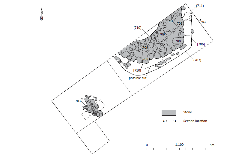
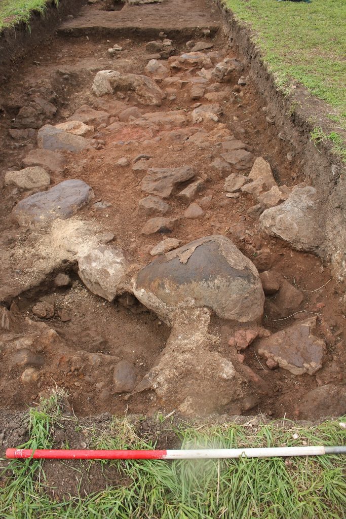
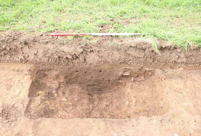
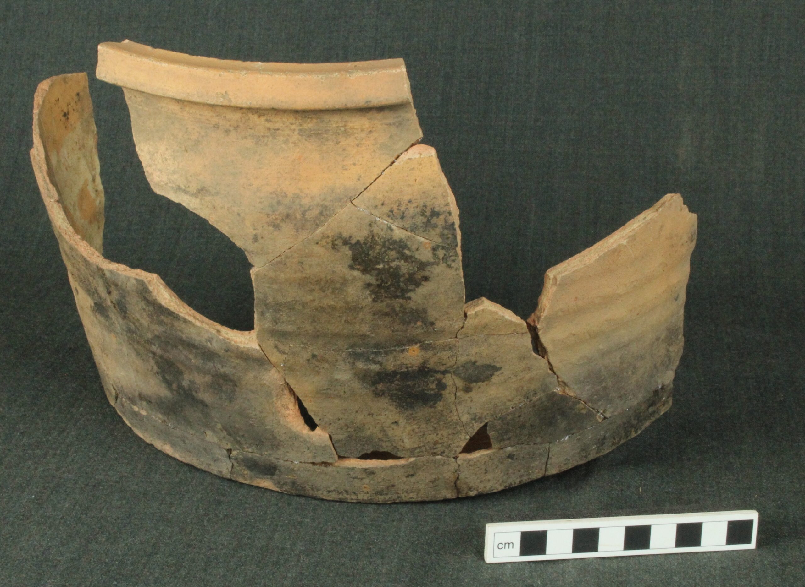
Trench 7 yielded the most information about the site. On opening the trench, a layer of rubble and mortar was revealed underlying the topsoil at the north-eastern end of the trench. At the south-western extent of the trench, a deep soil layer of soil was revealed surrounding a stone feature. The deep soil layer was revealed to be a moderately compact dark red-brown sandy silt with inclusions of occasional sub-angular stones and frequent charcoal flecks. This was interpreted as a buried soil surface possibly relating to medieval/post-medieval occupation. The stone feature comprised several sub-squared and rounded stones measuring forming a feature 2m long by 1.33m wide. The function of the stone feature is unclear but might relate to post-medieval agriculture on the site. The layer of rubble and mortar in trench 7 covered approximately two-thirds of the north-western end of the trench. The rubble layer contained several fragments of medieval ceramics, some of which, in addition to the presence of a fragment of glazed floor tile, indicate the presence of a building of some status. Below this rubble layer, which was up to 0.2m deep in places, was a large curving wall foundation consisting of several large sub-rounded and sub-squared stones containing a tightly packed fill of rubble and light red sandy gravel (Figure 3). A light yellow/cream sandy lime mortar was evident on the southern side of the curving stone foundation. A radiocarbon date sought for charcoal contained within the mortar returned the earliest date range for the construction of the wall as 1295-1400 cal AD (SUERC-93261). The wall measured up to 2.10m thick at its widest point and approximately 6m of the curve of the wall was visible in the trench. A thin but steep cut surrounded the southern side was interpreted as a foundation cut for the wall. A section through this revealed it to be filled with a friable mid-brown sandy silty clay, containing a few fragments of medieval ceramic and animal bone.
Trench 2 contained a single linear feature measuring 2.6m wide and 0.2m deep, running east-west across the width of the trench. In section, the linear had gradually sloping sides and a flat base. Sherds of likely medieval pottery were recovered from the fill which consisted of dark blackish grey gravelly silt with frequent round stones. It is possible that this linear represents an agricultural feature dating from the medieval period or later. Nineteen sherds of Scottish white gritty ware ceramic which join to form a complete profile of a substantial, well-thrown cooking pot with a square rim were recovered from the fill of the linear.
Trench 3 was placed to target anomalies identified in the geophysical survey. However, all that was found on excavation was a pair of field drains.
Trench 5 was opened by hand and revealed a deep stratigraphy of soil, rubble and post-medieval materials. A modern waterpipe was also encountered in the southern end of the trench. The deep stratigraphy encountered in this trench is likely the result of agricultural activity, and landscaping in the post-medieval and modern periods to extend and flatten the field for maximum yield.
Trench 6 targeted a high resistance anomaly in the eastern side of the field visible on the geophysical survey. This was revealed to be a dense clay natural subsoil. Cutting through this clay subsoil was a linear running SE-NW, visible on the geophysical survey as a low resistance anomaly. The linear measured 0.5m deep by 1.75m wide. The fill consisted of a dark orange-brown firm silty clay. One sherd of ceramic was recovered from the fill and possibly dates to the 13th century.
Trench 8 revealed a thin layer of the same medieval/post-medieval soil that surrounded the features in trench 7. However, on removal, no features were underneath. A few sherds of ceramic were recovered from the topsoil, most of which date to the 12th or 13th centuries.
A field drain running roughly NW-SE was encountered in the eastern end of trench 9. In the western end of trench 9 a linear running WNW-ESE was uncovered. Measuring 1.4m wide and up to 0.2m deep, it was filled with a loose mid greyish brown sandy silt with occasional charcoal inclusions. A sherd of black fabric ceramic and a square nail were recovered from the fill.
The Artefacts
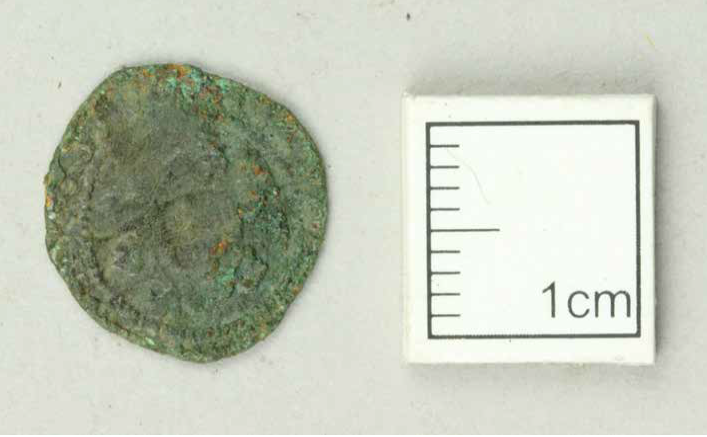
Several finds were recovered during a metal detecting workshop undertaken as part of the community training during the fieldwork. The metal finds assemblage is dominated by building fixtures and fittings, including 37 nails, and also includes coins, dress accessories, knives, and horse equipment. This assemblage represents the remains of agricultural and daily household activities. The majority of the finds are long-lived types and cannot be closely dated, as well as post-medieval and modern finds recovered from topsoil or agricultural plough soil deposits. The only dateable finds within the assemblage are the copper alloy coin of James IV that dates from 1488-1513, and the iron horseshoe nails, which are also consistent with a 15th to 16th century date.
The ceramic evidence, however, yielded far more information. The assemblage was assessed by George Haggarty, and his findings are summarised below.
Some of the potsherds discovered during the excavations can be categorised as Scottish White Gritty Ware (SWGW). SWGW is a broad term that covers a wide range of visually similar pottery fabrics recovered from excavation throughout large areas of Scotland, from at least the mid-twelfth through to the late fifteenth centuries. The main vessel types are cooking pots and jugs, although a limited range of other vessel types have been recorded. White gritty wares dominate medieval assemblages from Fife, Lothian, and Borders, often representing over ninety per cent of the medieval pottery recovered. Presently, the full extent of this industry and the distribution of its wares is little understood. There are likely a great many as yet undiscovered production centres; only three production centres have been identified with confidence. One of these, Colstoun, is in East Lothian and some of the white gritty ware sherds recovered from Morham may have been produced there. Only one of the cooking pot rims did not have parallels with the material from Colstoun. The sherd in question has decoration more associated with 12th century rims recovered from fieldwalking in Fife.
A sherd of probable medieval glazed floor tile was recovered, as well as some sherds from later imported French Loire-type jugs. These smallish jugs frequently have have small spots of a yellow, amber or, rarely, green lead glaze on their exteriors, apart from which they are undecorated. The source of these vessels has yet to be confirmed, and the assumption that they come from the Loire Valley should be treated with caution. These jugs tend to date to the sixteenth or, more often, the early seventeenth century. Taken together, the floor tile and jug sherds suggesting that there was a building of some status somewhere in the vicinity.
What looks like pantile shards from trench 5 suggest occupation on the site in the 18th century since Scottish pan tiled covered buildings were not common before that. It not known when the importation of Dutch pan tiles began, but in the 1680s there is a reference to Richard Drury, a skipper at Bo’ness, carrying a consignment of Dutch ‘leaded tyll’ for the roof of Kinneil house. There is also no good evidence to suggest that pantiles were being produced in Scotland before the beginning of the 18th century.
Discussion & Conclusions
Several archaeological features were encountered during the evaluation, with the most significant being the substantial remains of the foundations of a curving wall in Trench 7 which appear to represent the heavily dismantled and robbed remains of a curved wall. The wall was up to 2.0m wide, which would seem rather thick for a domestic house. It is, therefore, possible that this curving wall foundation represents the remains of a curving tower or stair tower of a fortified structure such as a castle. Since the site has long been suspected as the site of Morham Castle, as noted on the OS 1850s map and also mentioned in other historic accounts, this wall most likely represents the remains of Morham Castle. A radiocarbon date from the charcoal contained within the in situ mortar deposits on the foundation stones of the wall returned a date of 1295-1400 calAD (SUERC 93261), which is earlier than any mention of a castle in the lands of Morham. However, as mentioned above, nearby Yester Castle had been established as early as 1267 by Sir Hugh Gifford, a prominent landowner in the Lothians. Since Morham had been inhabited by the Anglo-Norman Malherbes from at least the late 12th century, it is possible they had a residence at Morham and this occupation may be reflected in the findings during the excavation of several sherds of 12th and 13th century ceramics. Although some of these were recovered from topsoil deposits, a few sherds were recovered from linear features in the field to the south of the structural remains. Further sherds were recovered from the cut for the wall, which may have been backfilled with nearby midden material or other occupation debris. It is unclear what form the residence at Morham would have taken in this early time although the findings from the excavation hint that there could yet be further evidence for an early residence at this site. The radiocarbon date for the earliest construction of the wall itself falling between 1295 and 1400 is particularly interesting. As explained above, during this time the lands belonged to the descendants of the Anglo-Norman Malherbes’ under the toponym of ‘Morham’. Sir Thomas of Morham owned the land in 1295 and owing to his subsequent capture and incarceration, and the involvement of his two sons in the struggles of the Scottish Wars of Independence, it is unlikely that a castle would have been constructed during this time. It is possible that Sir Thomas built the castle after he was granted back his lands in 1322 (see above) and before his death; however, after costly battles and a lengthy incarceration it does seem unlikely. It is far more likely that this part of the castle may have been constructed after the close of the Second Scottish War of Independence at a time when the Scottish nobles could resume their castle building and the tower house begins to emerge. Although the 15th century account of Morham refers to it as a ‘house and castle’; the 16th century account does mention the ‘tower’ and fortalice. The precipice of land that is indicated by the 19th Century OS Map as the site of the castle, where the substantial curving wall was found, is relatively small. However, the land may have encompassed part of the field to the west where the road and current house sit, as both are comparatively modern. Certainly, the presence of several linear features containing medieval pottery to the south of the structural remains seems to indicate that the land surrounding the site was also used during this period. Excavation further north and west of where the current remains have been uncovered may yet yield an answer.
Construction in the latter half of the 14th century would name the castle builders as the descendants of Euphemia Morham and John Gifford before the lands pass through marriage to the Hays, which comes a century before the mention of the house and castle of Morham in the mid 15th century. A coin found near the foundation remains dates to the reign of King James IV (1488-1513) and coincides with the Hepburn acquisition of the land. The artefact evidence from the excavations supports occupation at Morham from as early as the 12th century but does cover the latter medieval periods as well. The assemblage represents the agricultural and daily life of a medieval household which appears to be of some status, which would be expected of an occupied medieval castle. Coupled with the excavation results and the historical accounts, it is likely that the remains of the substantial curving wall uncovered by the excavation represent part of the medieval castle at Morham.