
Alongside the Whiteadder archaeology project, Historic Environment Scotland’s Rapid Archaeological Mapping Programme (RAMP) team have been analysing the LiDAR dataset, updating the National Record of the Historic Environment (NRHE) and verifying new discoveries in the field. Archaeological survey manager George Geddes discusses some of the initial results.
New technology often brings different ways of working, and the increasing availability of high-resolution LiDAR data is an exciting prospect for archaeological survey. The Rapid Archaeological Mapping Programme at Historic Environment Scotland is an initiative to explore how we make best use of this data by developing methods that allow us to work quickly and consistently. Our project using the Whiteadder LiDAR dataset is one element of this Programme and began in late 2019 and is due for completion in 2020. The survey has a number of discrete phases, beginning with assessment of what is already known, progressing to desk-based mapping and then field work, and finally to updating of the database, where the survey results will be available through Canmore.
We started our survey by reviewing the roughly 700 archaeological site records already in our database (Canmore). These records are a fascinating mix of information from many different sources, collated during more than a century. Understanding what is already known is a good starting point, and illustrates the changing scope of survey, as, for example, 19th century sheepfolds and enclosures have come to be seen as worthy of record in a broadened view of what constitutes our historic landscape. Recognising that defining the scope of a survey is important, our survey project is focussing on recording discrete abandoned remains dating to the period before about 1900 AD, such as farmsteads, settlements, folds and quarries.
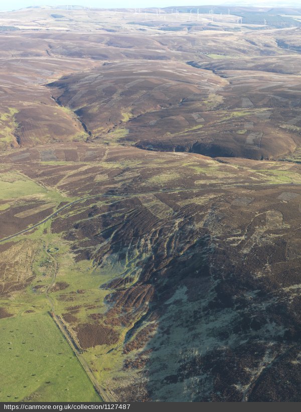
In planning our survey we have also considered the likely impacts of historic and recent land use patterns on the character of archaeological remains. The Historic Land-use Assessment map documents aspects of this patterning in the landscape and is a useful tool to help think about the implications of such patterning for survey. For example, relatively intensive drainage and ploughing since the 18th century across many low-lying areas has caused many prehistoric and medieval sites to have been levelled or removed. However, digging of drains and ploughing have also led to the discovery of numerous objects, cists, cairns and burials, while otherwise buried sites can be revealed from the air as cropmarking in arable fields. This nicely illustrates the interplay of historic and modern land use and the opportunities for archaeological survey. Thus, while extensive forestry and peat cover are major limitations on what we can observe through survey in such ground, unimproved grassland and heather moorland are often a zone of preservation of remains, spanning the period from prehistory to the recent past.
Building on a review of the existing records, we undertook a systematic desk-based search of the study area. This was undertaken in a Geographic Information System that allowed us to draw on different visualisations of the LiDAR, aerial photographs and multiple versions of Ordnance Survey maps from the 19th century to present. This phase resulted in the discovery of about 1,100 new features (a 160% increase), which were assigned a level of confidence in the interpretation as either high or low. This confidence scoring is designed to identify those remains whose interpretation is uncertain, for which a field visit is required, and those for which the LiDAR and other sources provide enough information to be certain of.
The field work phase that followed aimed to visit sites that we were not sure about from the desk-based mapping, as well as some of those recorded in the past. While this was interrupted by COVID-19 lockdown, by mid-March 2020 we had visited about 330 targets in a vital process of improving interpretation for some remains and dismissing others that proved to be natural when visited in the field. This has proved useful in helping us learn how to work with the LiDAR data in combination with the traditional survey approach of boots (and eyes) on the ground.
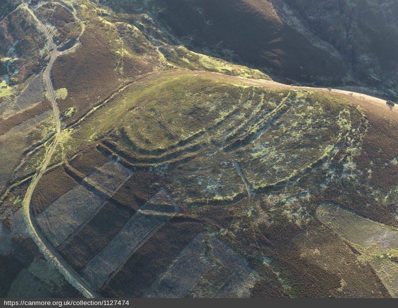
While the project isn’t finished, we can make a few observations on the basis of our work on the project to July 2020. We expect to add some 1500 new records to the database for the area, a significant enhancement of our knowledge about the historic environment. New discoveries of prehistoric monuments have proved rare, a reflection of the relatively high levels of previous survey activity in the area. However, for the medieval period there are a small number of new discoveries of farmsteads, and the LiDAR data also proved useful to the study of some well-known sites such as Billie Castle, a stunning example of Scottish tower house with extensive outworks, or Bunkle where the survival of some vestiges of a medieval settlement between the castle and church has long been suspected. It is for the post-medieval period that our survey has brought the richest results. These include more than 260 circular turf or stone-built sheepfolds, braided trackways, 30 farm dams (which powered threshers) and a handful of shieling sites. Other elements of the 18th and 19th century landscape are farmsteads and workers’ cottages, for which the combined use of historic maps (such as Forrest’s excellent Haddingtonshire of 1802) and LiDAR proved especially effective.
There is no question that our survey work, undertaken rapidly and with a heavy reliance on the LiDAR data, has brought with it a major increase in site numbers. The survey has also effected significant change in the character of the archaeological dataset to more fully document the post-medieval period remains – an important period in the formation of the landscapes which we now inhabit.