
Morham: The Search For A Lost East Lothian Castle
In the 12th century an imposing castle overlooked a secluded river valley near Haddington in East Lothian. The tower was the residence of the Morham family, who give their name to the village found there today. By the 18th century the castle was gone, destroyed and the stone robbed for the construction of other buildings. No trace is visible today, though the position is marked on several historic maps.
History
Thomas de Morham, previously known as Thomas Malherbe, was granted the lands of Morham in the 12th century. It is likely that the castle in some form also dates from this century. The Morhams owned the lands until 1322 when the estate passed into the hands of Sir John Gifford, of Yester. The lands of Morham change hands several times, even being granted by kings. In 1585, the document that grants Morham and Hailes to Francis Stewart, mentions the “tower” and “fortalice” of Morham; confirming the presence of a fortified structure on the site. The castle was fortified again in 1593 and after this there are few mentions of the castle until the 18th century. The old Statistical Account of the 1790s mentions that “although there is not one stone of the castle… left upon another, yet there are many people alive who remember the remains of it, and speak of it as a large extensive structure”.
The Site?
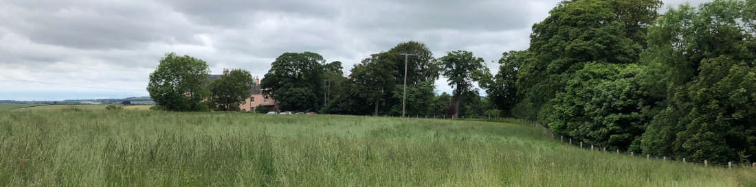
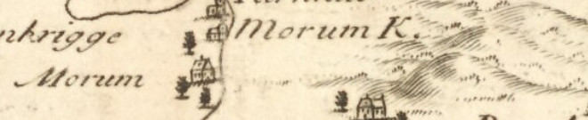
The site of Morham Castle is best known from the mapping evidence. Below is an extract from the 1st Edition Ordnance Survey Map where the “Site of Morham Castle” is marked. The site of Morham Castle is also mentioned in the old Statistical Account of the 1790s and is stated to have been “on an eminence, near the church”. Similarly, the new Statistical Account states that it is “on a point of land near the church, and overlooking the glen below”.
You can look for evidence of the castle’s location on the National Library’s mapping website, here.
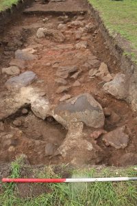
Trench seven revealed a layer of crushed stone and mortar rich in finds of animal bone, oyster shells and medieval pottery, just under the topsoil, which appeared to form a demolition deposit; and on the removal of this material larger stones began to appear. When fully revealed, these stones formed part of the foundation of a substantial, curving stone wall. A large cut had been excavated to insert the wall foundations, which had been constructed of large sub rounded and sub squared stones and boulders, aligned to form the outer and inner faces of the wall and smaller stones packed with sandy gravel forming the inner fill material. The wall was at least 2m thick at its widest point and appears to have belonged to a large rounded tower or stair tower; suggesting that it could have once formed part of Morham Castle. The finds from the rubble and mortar layer suggest occupation of the site from the 12th to the 18th century which is also consistent with the historical evidence for the occupation of Morham Castle.
Several of the other trenches (6, 2 and 9) revealed shallow linear features which contained pottery of a medieval or later date, although it is unclear whether these features are contemporary with the castle.
During the excavation, participants received training in archaeological drawing, metal detecting, survey, site formation and recording, and artefact recovery and recording. During our metal detecting of the spoil heaps from the trenches, one of our youngest volunteers even found a coin.
We are now back in the lab, washing the finds and processing the samples. Analysis of the finds and radiocarbon dates obtained from our samples will hopefully confirm the dates for our features. We’ll update this page once our analyses are complete.