
This page presents a summary of results of work in the Bothwell Water Valley. You can read the report here.
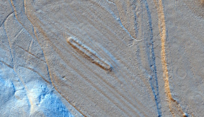
In February 2019, excavations were undertaken in the Bothwell Water Valley at the site of an unusual feature identified in the LiDAR data. The low remains of what appeared to be a very long, narrow structure were spotted on a low river terrace, within an area of previously recorded rig and furrow cultivation. The building was on the same alignment as the rig and furrow, which could explain why it has never been noticed before; it was essentially hidden in plain sight.
The building survives as an upstanding earthwork consisting of a continuous rectangular low bank forming a feature roughly 47m long by 7.5m wide with rounded ends, orientated northwest-southeast. No entrances are immediately identifiable on the ground.
Excavations revealed that the walls of the structure were around 0.6m wide, surviving up to three courses high. They appear to have been formed of stone and turf: collapse/decay deposits contained patches of material consistent with decayed turf as well as a wealth of medium to large stones and boulders, presumably indicating that the walls originally stood to a substantial height with turf elements, perhaps toward the upper parts of the building. A radiocarbon date obtained from a collapse/decay deposit in the interior of the building, directly on top of the original ground surface deposit, which ran underneath both of the walls, returned a date in the second half of the 13th century.
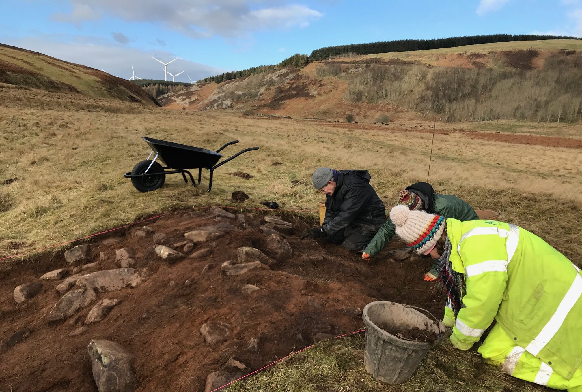
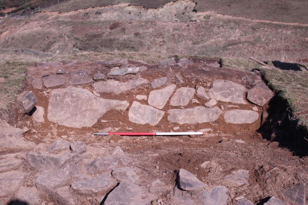
Running alongside the western wall of the building was a rather slighter wall which appeared to meet the building at either end, forming an annexe of sorts, perhaps 2m wide, along the outside of the building.
No internal floor surfaces or features were evident inside the building. It is possible that the limited trenching missed any evidence for these, but it is also possible that the building was not constructed with any.
At 47m long and 7m wide, it is unlikely that the structure represents a domestic or residential building. It more likely represents an agricultural structure, perhaps an earlier form of the linear sheephouses marked on (and so predating) earlier OS maps. Wool had become so profitable in the early medieval period that ‘every available acre in the Borders… was grazed by sheep’ (Walling 2014) and in particular the monastic sheep flocks were substantial, with 20% of Scottish wool being produced by just the Cistercian houses. The lands where the Bothwell long building is situated were gifted by Earl Cospatric to the monks of Kelso in the 12th century (Smith 2011). The rent rolls for Kelso Abbey in 1290-1300 show that they held between seven and eight thousand sheep in one valley alone (Walling 2014), indicating just how significant their flocks (and the resulting income) were.
Medieval sheepfolds are markedly different from the temporary open structures of the 19th and 20th centuries since they were used to house sheep for long periods. Walter of Henley, a 13th-century writer on agricultural affairs, recommended that sheep were ‘housed’ in sheepcotes between Martinmas (11 November) and Easter (Dyer 1995).
Dyer (1995) has identified earthworks representing the remains of several medieval sheepcotes across the county of Gloucestershire. The structures range in dimensions from 23-65m long and 6-10m wide and survive as earthworks of the foundations of long buildings, often with surrounding field systems and features. It is estimated that between 1250 and 1550 at any one time there may have been as many as 300 similar sheepcotes in use in Gloucestershire alone, and evidence for them also survives in other counties throughout England (Dyer 1995). They were well constructed, weatherproof buildings and used to house entire flocks of sheep through the winter nights, sometimes costing as much as half the yearly revenue earned from the profits of sheep farming. Manorial records from the 13th and 14th centuries provide an insight into their construction, recording stone-built, cruck framed tall buildings, with one recorded at a height of 3.7m. They typically served more than one use, often being used for lambing in the spring and were also sometimes to store materials. Sheepcotes were often located near fresh water, for use as sheep washing, and were used to collect manure for spreading on fields – indicating that the deep deposits would have been dug out after use (Dyer 1995).
The Bothwell Long Building is situated on a low rise in the river terrace surrounded by rig and furrow and a metaled track – which could have removed evidence for any surrounding field systems and features. It conforms to the dimensions and records of the medieval sheepcotes identified by Dyer (1995) in Gloucestershire and other parts of England. The lack of internal features is perhaps not surprising as a sheepcote would not have needed any. The lack of floor surface, formal or informal can be attributed to the practice of manure accumulation, whereby at the end of the life of the structure it would have been thoroughly cleaned out of all valuable accumulations for use on the fields. The excavations at the Bothwell long building have revealed a well-built structure with evidence for an external annexe. Its form and construction are consistent with similar structures in England identified as the remains of medieval sheepcotes. Documentary evidence confirms that medieval sheep farming was being undertaken in the area as early as the mid-12th century by the monks of Kelso Abbey. Although this structure is not confirmed to date from as early as the 12th century, the structure does pre-date the OS mapping evidence and the other sheep husbandry structures in the valley. Relatively little evidence remains of rural life in medieval Scotland. There are few surviving remnants of deserted medieval villages and farms in comparison with England (Dixon 2002). If this structure is the remains of a medieval sheepcote, it serves to demonstrate the long-lived sheep farming heritage of the Bothwell Water Valley and also provide a keen insight into the importance of the medieval sheep farming industry.
Bibliography
Dixon, P, 2002. Puir Labourers and Busy Husbandmen: the Medieval Coutnryside of Scotland 100-1600. Edinburgh: Birlinn with Historic Scotland.
Dyer, C, 1995. Sheepcotes: Evidence for Medieval Sheepfarming. Medieval Archaeology, 39:1, 136-164, DOI: 10.1080/00766097.1995.11735578