
This page presents a summary of the results of work at Bunkle. You can read the full report here.
Introduction
In May 2019, excavations and associated works were carried out to the east of Bunkle Castle by Bunkle and Preston History Group (BPHG) with the assistance of Richard Carlton of the Archaeological Practice, Ltd. In 2020, AOC carried out the greater part of the specialist analyses as part of the Whiteadder Project. This page summarises the results of this work.
The site lies at the foot of Bunkle Edge, a ridge on which numerous prehistoric forts, earthworks and pit alignments are known. A church is first documented at Bunkle in the late 11th or early 12th century. A Norman apse – its vaulted arch later used as a burial vault for the Home of Billie family – and the chancel arch survived the demolition of the rest of the church in 1820. The origins of the associated castle may be a little earlier than the church.
In its earliest form, the castle conforms with the characteristics of a motte, raised by up to 8m on the south-west, south, east and northeast sides where it is associated with an outer ditch, or moat. Motte-and-bailey castles in Scotland emerged as a consequence of the centralising of royal authority in the 12th century, when David I encouraged Norman and French nobles to settle in Scotland, introducing a feudal mode of landholding and the use of castles as a way of controlling the contested lowlands. While their construction in Scotland appears to have continued longer than elsewhere in the British Isles, until at least the end of the 13th century, the date of foundation of Bonkyl castle is likely to be broadly contemporary with the church in the late 11th or early 12th century. Later, the castle passed by marriage from the eponymous Bonkyl family in the late 13th century to Sir John Stewart, whose descendants were created Earls of Angus, and is likely to have remained in permanent or near-permanent use thereafter until 1544 when destroyed by the Earl of Hertford during the ‘Rough Wooing’. This seems to have led to its permanent abandonment, although the associated village remained under the ownership of the Earls of Angus until the late 18th century, when it passed to the Earls of Home.
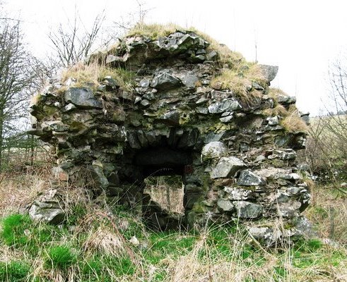
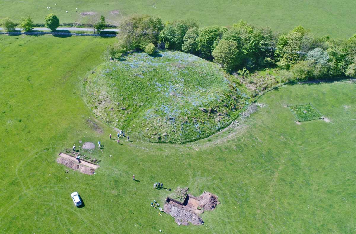
The remains of Bunkle Castle are visible today as a raised sub-circular mound, rising c. 5m above the fields to the south, with remains of an encircling ditch. A gap in the mound on the south, towards the church, may indicate an entrance. At the northernmost point, close to the road, are remains of a straight length of curtain wall, The standing remains represent c. 20m of wall; beyond there is a gap of c. 10m, and then a taller upstand of masonry 4m high, where the faced wall seems to turn at approx. 90 degrees to run south-east. In this upstand is a narrow slab-roofed passage running more or less due north. At first sight, this looks like the internal recess of a loop, the outer face of which has been robbed away, but the line of the west side of the passage can be traced as continuing footings c. 4 m further north, as if there were a projecting tower at the angle of the north-west and north-east curtains, perhaps containing a postern. Alternatively, this might have been part of a larger gatehouse here and the ‘passage’ gave access to a chamber in the eastern of two flanking towers.
The continuing existence of the associated village of Bonkyl is referenced in medieval and later documents, although its exact location remains unknown.
Previous Work
In 2017, a metal detecting exercise was carried out in the area around the castle and an adjacent ploughed field to the north-east. This produced a modest finds assemblage comprising 40 artefacts related to daily life and agricultural activities from the 18th century onwards.
In the same year, BPHG commissioned Rose Geophysical Consultants to carry out geophysical survey over an area of approx. 5.5ha between Bunkle Church and Bunkle Castle which identified anomalies just to the south-east of the castle which, it was suggested, would benefit from further study.
In May 2018, BPHG carried out exploratory trenching, testing some of the anomalies revealed in through the geophysical survey. This work revealed tantalising hints of medieval activity at the site, including curving features formed of lines of truncated ash, alder, and oak posts. A small assemblage of medieval pottery was recovered. Palaeo-environmental analysis provided evidence for waterlogged preservation, with indications that the feature held standing water at least periodically. A small charred assemblage of organic material is characteristic of domestic hearth waste and included cereal crops typical of medieval and post-medieval sites, while a grape pip reflects the use of imported dried fruits at the site. Radiocarbon dating suggests very early, potentially pre-Conquest occupation of the site.
Excavations in 2019
The excavations took place on the east and south-east sides of Bunkle Castle, between the south-east side of the castle moat and the east side of the churchyard wall, a linear distance of some 300m. The objective of the fieldwork programme was to identify and record any archaeological features uncovered during groundworks, with the intention of adding to knowledge previously gained through documentary work by BPHG members of medieval settlement at Bunkle.
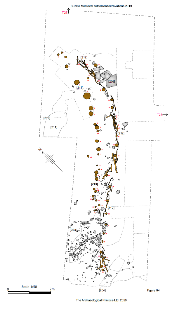
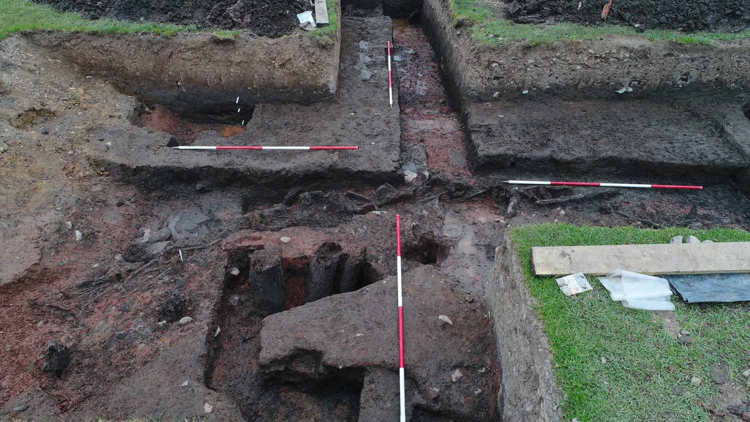
Trench 2 was placed to re-examine and expand upon the same numbered trench opened during previous work. The key finding here was a channel-like feature, some 11m-13m wide, perhaps up to 48m long and at least 0.7m deep which runs on a NW-SE trajectory from the south-east side of the castle moat, with which it may once have been connected. Within this channel, running SW-NE across the north-east end of the excavated portion, is a feature comprising two lines of wooden posts, that on the SE side furnished with wattle infill, which has been dated by means of three radiocarbon dates to the 14th century. Dendrochronological analysis of a large oak post within this feature indicated Germany as a possible source fort the post, and produced a rather anomalous late 16th or early 17th-century date, which might indicate re-use of this feature in the 17th century or later.
Trench 4 revealed deposits of unworked stone rubble amongst which a stone wall was defined, at and slightly below turf level, 0.70m-0.80m wide and built of two parallel lines of rough facing stones with a rough stone core.
Trench 5 revealed a very shallow depression, 0.12m deep, cut 0.40m below current ground level. The surface of the cut was impressed with shallow depressions interpreted as possible hoof prints.
Trench 6 was positioned with two branches across and along a slight, 10m wide linear depression, visible before excavation. This depression was oriented NW-SE on the same projection, and apparently part of the same feature as an infilled cut exposed in Trench 2. The northern branch of the trench, oriented SW-NE, exposed the cut of an apparent channel feature on the west side of the trench with a corresponding cut on the east side. A further apparent cut was revealed at the south end of the southern branch of the trench. The linear channel marked by these three cuts was filled with a light grey, silty loam. On the lip of the linear depression, above these cuts, were accumulations of stone pressed into the surface of the subsoil as if to create working surfaces or platforms, perhaps even the foundations of built structures.
Trench 7 was a linear trench cut on a NW-SE trajectory south-west of T6, on the same orientation as both T2 & T6, placed to investigate an apparent depression visible as a slight earthwork before excavation. Excavation revealed a rather complex stratigraphy apparently created by the excavation and subsequent re-excavation, or cleaning, of a deep, steeply-cut ditch that was 1.9m wide (at the top) and up to 0.77m deep. The ditch was found to be part of a complex of cut features which appeared to consist of a pre-existing, rather wide and shallow ditch or depression which had subsequently been re-cut at least twice prior to the excavation of deeper ditch.
Trench 8 was excavated south-east of Trench 7 to investigate an apparent roadway running E-W across the south part of the field. The roadway was found to be an ad hoc modern construction directly upon the subsoil, containing modern brick and tile at its surface with no indication that earlier surfaces had existed beneath.
Trench 9 was aligned E-W in the east part of the site, with its eastern end close to the middle section of the west side cemetery wall, south-south-east of Trench 4. It contained two significant ditches.
Trench 10 was positioned in the central part of the site on the eastern edge of apparently disturbed ground containing a range of earthwork features visible on the ground (and even more prominently using Lidar) as slight linear and sub-circular depressions. Its NW-SE alignment was placed to investigate an apparent plateau on the fringes of rig & furrow earthworks but uncovered no features of note.
Trench 11 was positioned to sample the north part of the site close to the main, modern access road to the church, but uncovered no features of note.
Artefacts
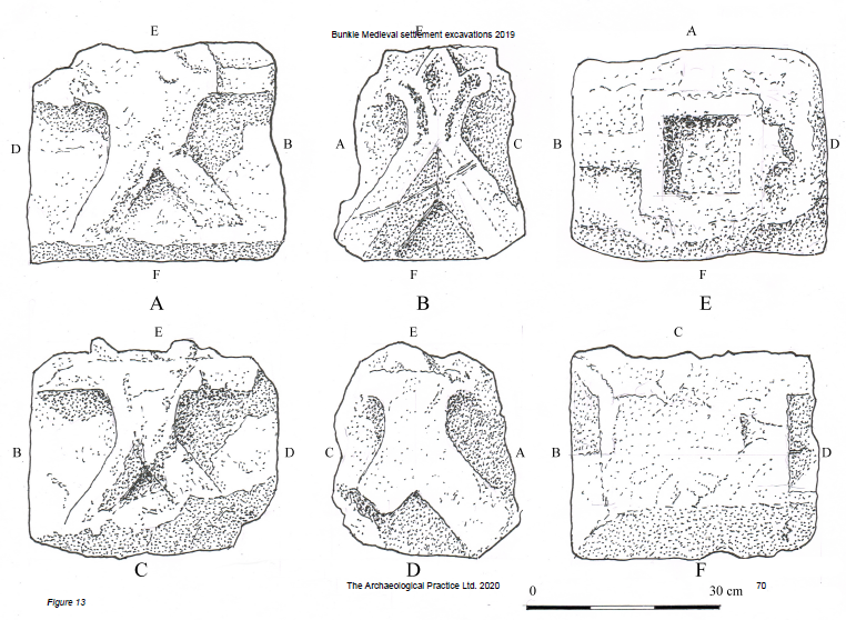
A carved red sandstone decorative gable ornament was discovered during the excavations in 2019. It is medieval in date, perhaps 13th or 14th century, and would have adorned a building of some status.
The ceramics included several assemblages of conjoining sherds, each representing a single vessel. An assemblage of 36 sherds included 31 which conjoin to form the rim, neck, shoulder and strap handle of a jug in an off-white lightly sandy and slightly gritty fabric covered with a light green suspension glaze. This is almost certainly a 13th or 14th century Yorkshire import, possibly from the Brandsby area where kiln material has been identified.
Five conjoining sherds form a large fragment of a thick, crudely made, handled vessel with a light green lead glaze on the lower part of its interior, and sooting on its exterior. The red sandy fabric has a reduced core and no visible large inclusions. It is somewhat similar in appearance to late 16th century, Scottish Post Medieval Oxidised Wares, but given that the rest of the pottery sherds in the context are medieval, this vessel may be from an as yet unidentified Scottish kiln site or possibly an English import.
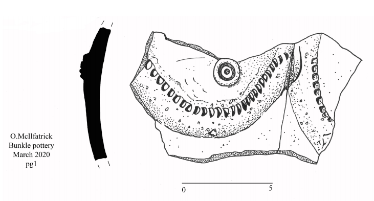
Over 70 sherds and frost derived flakes seem to come from the same large, globular, late medieval, green glazed, three handled, reduced ware jug, with a slight oxidised exterior. This is probably a variant of a type 6 three handled jug, illustrated in the Scottish redware typology (Haggarty Hall & Chenery 2011, 57, fig 67). Several somewhat similar green glazed, three handled pottery jugs have been recovered from the late 15th century garderobe chute at Bothwell Castle (Cruden 1952, 143-7). It is thought that these were produced locally at a pottery servicing both the castle and the wider area.
What evidence we have suggests that Scottish high medieval kiln sites did not continue into the 15th century. It is possible that as the burghs blossomed, pottery production moved closer to them, and there are abundant references which seem to confirm this (Haggarty, Hall & Chenery 2011, 13-21). By the 17th century, pottery production was moving again, this time attracted to the major rivers where large areas of estuarine clay had probably been uncovered by the removal of peat, and where the pottery and the new bulky fired pan tiles, could be moved cheaply by boat (ibid & 27).
Presently our knowledge of both medieval and post-medieval pottery production in the Scottish borders is very limited. There are several tantalising historical references which give us tantalising glimpses of a possible pottery industry in the area, but further documentary research, scientific analysis, and archaeological fieldwork, is required to enable us to fully understand the medieval and later pottery industries of the Borders.
Conclusions
Remains uncovered adjacent to Bunkle castle in 2019 added to the findings of a smaller excavation in 2018 in confirming the presence of channel and ditch-like features which appear, in origin, to date from as early as the early 12th century, but in some cases continued in use until as late as the early 16th century.
Foremost among these features was a channel-like feature, some 11m-13m wide, perhaps up to 48m long and at least 0.7m deep which runs on a NW-SE trajectory from the south-east side of the castle moat, with which it may once have been connected. Within this channel, running SW-NE across the north-east end of the excavated portion, is a feature comprising two lines of wooden posts, that on the SE side furnished with wattle infill, which has been dated by means of three radiocarbon dates to the 14th century. Dendrochronological analysis of a large oak post within this feature indicated Germany as a possible source fort the post, and produced a rather anomalous late 16th or early 17th-century date, which might indicate re-use of this feature in the 17th century or later.
The post feature is interpreted as perhaps some sort of barrier, perhaps as a combined barrier and walkway with planking nailed onto or across the upper surface of the uprights. It is possible (but unproven) that the channel and moat may once have been connected; in that case, it becomes possible to see the post feature as a barrier between the two, perhaps serving as a device to regulate water levels or related to fish management.
It is clear that these two features were both in use in the 14th century and the channel, at least, remained open until at least the early 16th century. However, the combined functions of these features are rather more obscure. It does seem clear that the large, channel-like feature contained standing water for long periods and that deposits accumulated within it at different rates and were subject to varying levels of disturbance. Whilst other options remain open, including a defensive purpose perhaps associated with an early phase of the castle or previous use of the site, these characteristics all point to the use of the cut feature as a fish pond in the 13th and 14th century.
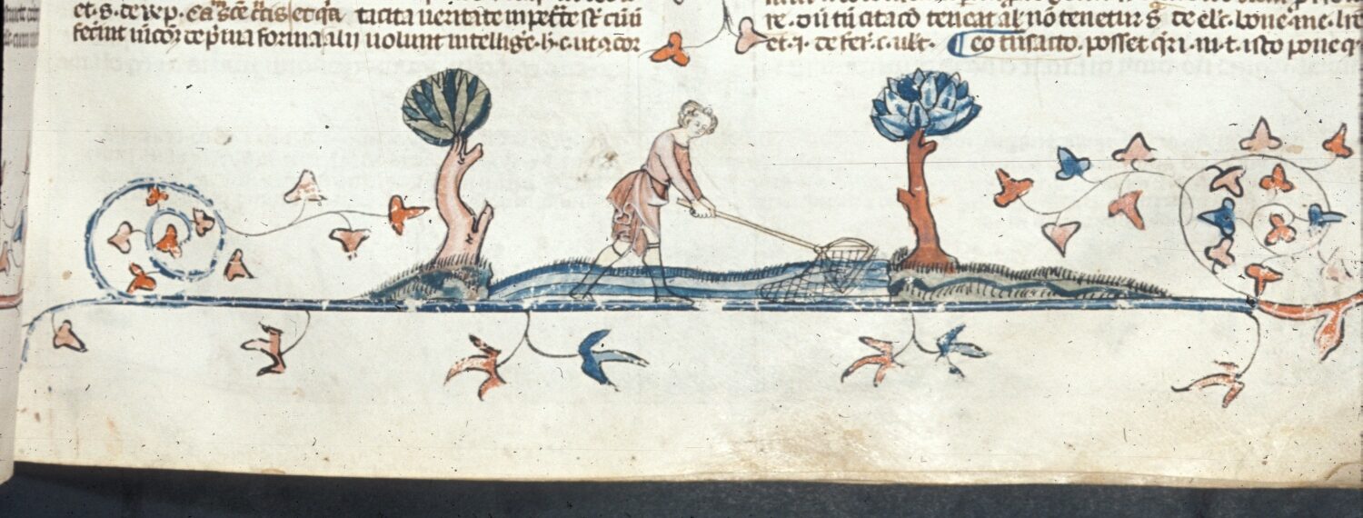
Fish played a vital part in the medieval diet as a relatively cheap source of protein and because of religious prohibitions on meat-eating. From the late 12th century, fish are frequently mentioned in accounts and court records. The number of fish pond sites claimed in Scotland is relatively small compared to England and Wales and it has even been suggested that medieval Scotland possessed no recognisable freshwater fish culture at all, but such features have nevertheless been identified at numerous medieval sites, including defensible ones.
Fish ponds are usually recognised by a variety of physical and contextual factors (and documentary evidence, if available) but specific diagnostic features are rare. Amongst their potential physical features are water channels, sluices, spillways and dams for water management, as well as clay linings and wattle hurdles at entry and exits points or used as aids for fish catching. The Moravian engineer Dubravius (1559) specifically recommended strengthening dams with rows of stakes or posts of elm, oak or ash to contain a core of brushwood or clay.
The species of fish mostly likely to have been kept in Scottish fish ponds include European eel, pike, perch and roach which are probably all indigenous species, as well as bream which seems to have been the species most favoured in medieval Britain. But it is pointed out that due to low yields, in the majority of cases, fish ponds are likely to have provided no more than a proportion of fish requirements to the estates they served. The relatively small fish pond suggested at Bunkle is likely to have served as no more than a supplementary source of fish for the top table of the castle, but may of course have served other purposes, whether aesthetic, sporting or defensive. Assuming it stood alone, the Bunkle pond could have been used to hold quantities of table-ready eels (which are easily transported overland), for example, or if associated with a larger holding pond locally – potentially in the present position of a small pond on boggy ground close to the church and Manse – to hold table-ready fish grown to maturity in the larger facility.