
This page presents a summary of the results of work at the Whiteadder Reservoir cairn. You can read the full report here.
Introduction
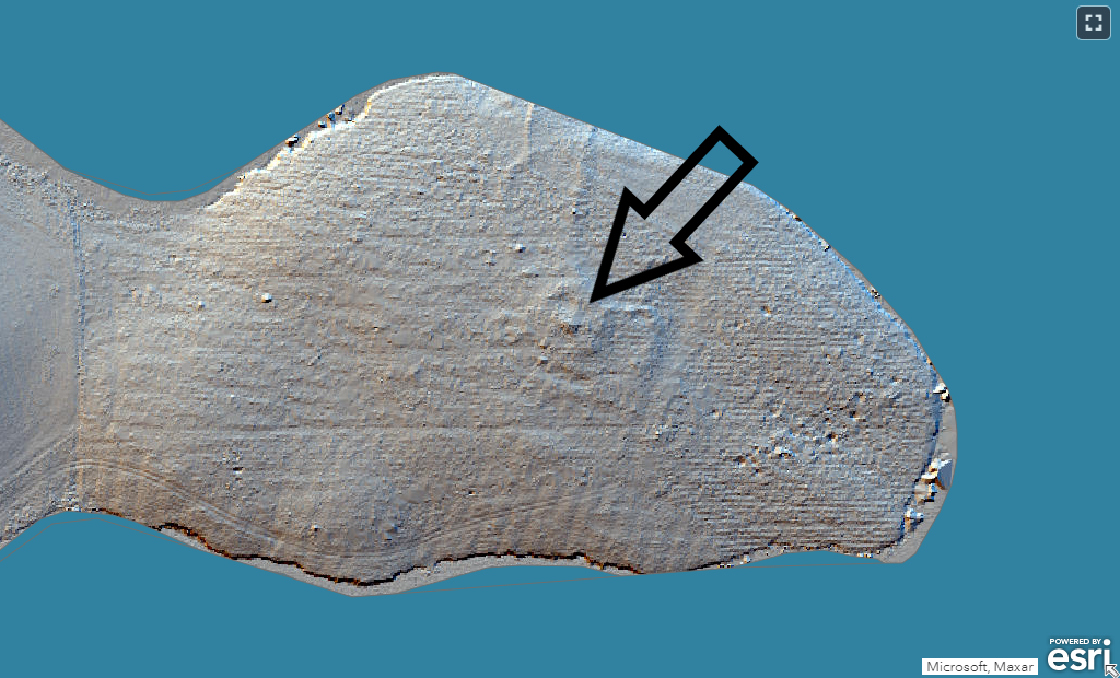
In March 2020, excavations were undertaken at the site of a possible prehistoric cairn that had been identified in the LiDAR data. The site is situated on a promontory which extends into the northern end of Whiteadder Reservoir. The reservoir was created by flooding the valley in 1968. Prior to that, the site would have been in an elevated position (a little over 800m above sea level) within the valley which, although lower than the hills around, afforded good views of good the surrounding landscape. The promontory is now forested. This must have taken place sometime after the mid twentieth century since the forestry is not marked on the OS One Inch 7th series map (1955-1961). The possible cairn is not marked on any maps and was unknown prior to its identification in the LiDAR data.
The landscape around Whiteadder Reservoir is rich in archaeological remains of all time periods, from prehistory to the post-medieval period.
Numerous other cairns are known nearby, including those on the summits of Spartleton Hill to the south and Spartleton Hill to the north, and on the shoulder of Pensheil Hill to the south-west. Further possible cairns are known to the north-west at Tavers Cleugh, to the south-east at Berrybank Wood. Funerary cairns typically date to either the Neolithic period or the Bronze Age, but a lack of excavated examples in SE Scotland means that that date of the Whiteadder cairns is not confirmed. Over the many centuries since their construction they are often reduced to low stony mounds, either through erosive deterioration or due to stone being removed for use in field boundaries, for example. The abundance of cairns in the area suggests that the landscape held a special significance in the past, and our cairn sits in the centre of it, lower but surrounded by various other funerary and ritual monuments and overlooked by Table Rings cairn, 800m to the WSW. The prevalence of early prehistoric monuments in the area renders it unusually densely populated with sites of this type compared to the rest of East Lothian and the Scottish Borders.
Conversely, there is less evidence for domestic activity in the form of roundhouses or field systems, perhaps because much of this was subsumed into the Iron Age and later landscape, or because the low traces of roundhouses and field boundaries have been obscured by peat growth in the intervening centuries.
Excavation
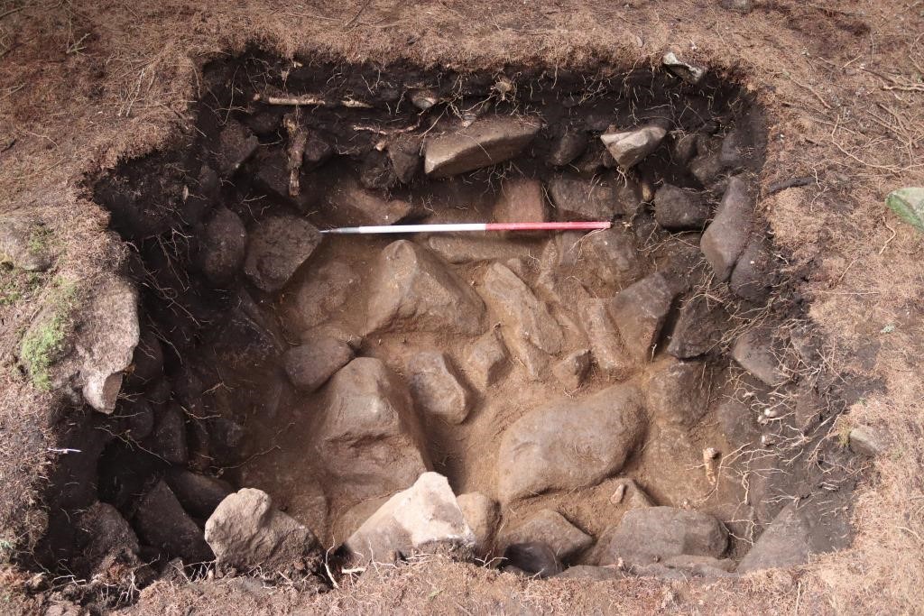
We opened two trenches: trench 1 was 2m x 2m trench roughly in the centre of the mound; Trench 2 was long and narrow trench and ran down the slope of the mound, to try to catch the edge of the cairn.
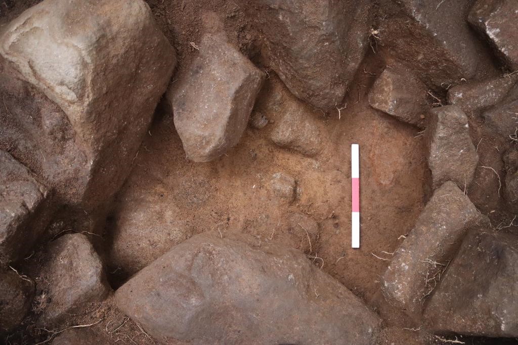
Beneath the overburden in Trench 1, we quickly revealed large sub-angular stones up to 0.6m in diameter but mostly closer to 0.4m in diameter. This is interpreted as cairn material. At the upper level the stones were loosely jumbled together but the cairn material became more densely compacted, and the stones became larger, at the lower levels. There was no clear transition between the upper and lower material, however, so all cairn material was treated as one context. The depth of cairn material was around 0.6m.
Beneath the cairn material was a mid yellowish brown, fine silty sand with gritty content and occasional sub rounded pebbles up to 0.04m in diameter. This deposit is interpreted as a possible old ground surface, and the surface onto which the cairn was constructed. It overlay the natural glacial till, which contained large granitic boulders. The British geological Survey extract notes that there are superficial diamicton (mixed) till deposits recorded in close proximity. These are deposits from the end of the last glacial (Devensian) and comprise a mix of clay and large stones which have been scoured from the underlying bedrock by glaciers and then redeposited. Glacial deposits such as this can be locally quite deep; given the size of the trench, and the size/weight of the stones within, we did not attempt to reach the bedrock.
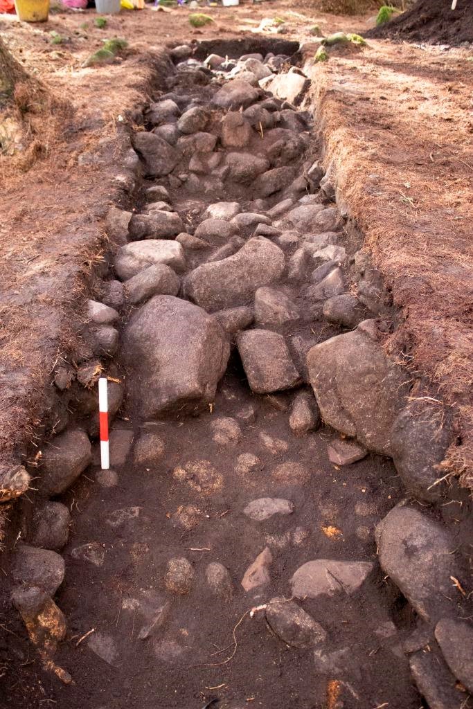
Similar cairn material was identified in Trench 2, as with Trench 1. A pair of large boulders sitting at the edge of the cairn material were interpreted as kerb/edging stones for the cairn body which had slipped forwards, either in antiquity or as a result of more recent forestry activities. Underlying these was a possible trampled surface/old ground surface around the exterior of the cairn. The flat stones throughout formed a rough paved surface, while secondary layers of flat stones suggest maintenance/upkeep of the area around the cairn. Further deposits underlying the cairn material were identified as old ground surfaces predating the construction of the cairn.
Radiocarbon dates were obtained for samples from two contexts. A fragment of charcoal (birch) from beneath the cairn material in T1 returned a date of 927 ± 26 BP (SUERC-93858), within the early 11th century AD. A fragment of nut shell (hazel) from one of the contexts underlying the cairn material in T2 returned a date of 2841 ± 26 BP (SUERC-93859), in the early 10th/late 9th century BC, within the late Bronze Age.
Artefacts
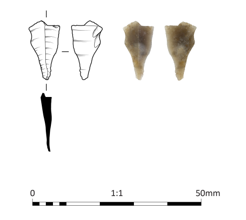
A modest assemblage of lithics was discovered. Much of this represented debitage with no secondary modified pieces. All of the material is in fresh condition with no signs of patination, burning or abrasion. All of the material can be characterized as being of local derivation. A single proximal bladelet fragment was identified, most likely of Mesolithic date.
It is probable that the material represents background early prehistoric activity within the area, which has been incorporated within the material of the cairn.
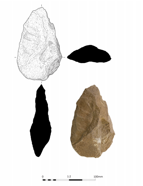
A fractured spall detached from the surface of a possible sandstone cobble hammerstone was retreived from the organic soil matrix (201) immediately underlying the topsoil. The roughly leaf-shaped fragment has few original surfaces surviving. Multiple fractured facets are observed indicating that the cobble this spall derives from has been struck from multiple angles. There is a small faceted area of possible wear, approximately 20 mm in length, at one end of the spall that may indicate use as a pounder prior to more vigorous use as a hammerstone. The fractured surfaces suggest multi-directional percussive use.
Sandstone is not the ideal material for use as a hammerstone as it is prone to shattering under impact, suggesting that the user chose it simply because it happened to be to hand, and discarded it after use. At Cloburn Quarry, in Lanarkshire, a similar sandstone hammerstone was found in association with a Bronze Age ring cairn (Lelong & Pollard 1998, 134). Like the example from Cloburn Quarry, the hammerstone fragment considered here could be an artefact relating to an earlier episode of activity on the site and incidentally incorporated within the make-up of the cairn or it could have been a tool used during the cairn’s construction and was subsequently added to the stones of the monument after it had broken.
A single rim sherd of low-fired handmade pottery was recovered from the soil overlying the cairn material in T1. Although only one sherd of this vessel survives, it displays sufficient characteristics to allow it to be identified as the rim sherd of an Early Bronze Age Beaker, decorated on the exterior surface with transverse rows of comb-impressions. The recovery of the sherd from soils above the cairn itself necessarily means that it is not possible to determine whether this represents the vestiges of a disturbed formal inhumation burial or a secondary rite associated with the cairn.
This sherd represents less than 5% of the circumference of the rim of a pot with an external rim diameter of at least 210 mm and from the profile that survives, a fairly short necked pot is implied. The external surface has been slipped and burnished to create a smooth background into which three closely and evenly spaced rows of transverse comb impressions have been added before firing.
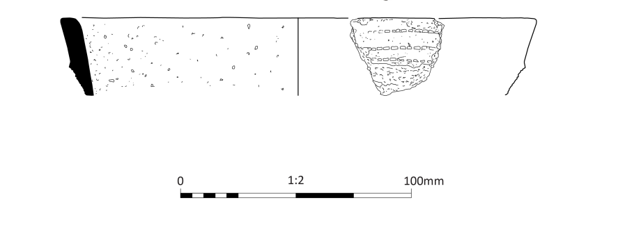
Though small, this single Beaker sherd represents a valuable addition to the known corpus of c. 50 Beaker finds from East Lothian and the (former) Berwickshire region, and provides tantalising hints at possible funerary or ceremonial activity at the site during the Early Bronze Age.
Conclusions
The anomaly identified on the LiDAR data can be confidently identified as the remains of a cairn, though much denuded, with stone possibly having been removed for the creation of banks/field boundaries and other features in the vicinity. It is probable that forestry activities have also caused damage and loss of stone, evidenced in T2 by linear truncation of the cairn material, on alignment with the planting layout of the trees.
The lack of any clearly defined structure within the excavated areas of the cairn material suggests that the cairn is more likely to be Bronze Age than Neolithic in date. Our excavations did not reveal any evidence of human remains, whether inhumation or cremation burials, but this is not surprising given the limited size of our trenches in relation to the size of the cairn.
The variation in the radiocarbon dating results indicates some influence of bioturbation or other disturbance to deposits on the site since both contexts were interpreted on excavation as being stratigraphically and chronologically secure. There are two possible reasons for the discrepancy in dates. Firstly, that the cairn is not in fact of prehistoric origin but represents much later activity, perhaps movement of stones for field clearance, with mixed residual material of prehistoric date being included within the cairn. Secondly, that the sample the produced a later date may have been contaminated, either through the effects of bioturbation or because material from an overlying (later) context was accidentally included within the sample e.g. having become dislodged from the section edge and fallen into the base of the trench during collection of the sample. On balance, the first option seems less likely. The inclusion of material of medieval date in a context overlying the natural suggests that at some point in the medieval or post-medieval period, the turf was stripped back to reveal the natural beneath. This would not have been necessary during construction of a cairn of stones resulting from field clearance since these would most likely have been placed directly onto the turf. Furthermore, the hillock on which the cairn sits clearly saw activity during the medieval and later period, evidenced by field banks/boundaries crossing the area, visible both on the ground and in the LiDAR data. One of these field boundaries appears to encroach on the eastern edge of the cairn, lying over the cairn material and so post-dating it. The effect of modern forestry ploughing can also be expected to have disturbed and intermixed deposits overlying and within the cairn.
The pot sherd supports a Bronze Age origin for the cairn, and suggests the cairn was in use over a long period. The sherd’s recovery from a deposit immediately beneath the topsoil and not stratigraphically secure, highlights the disturbed nature of the upper cairn material, whether during recent centuries or during the cairn’s active use in prehistory. Typically, Bronze Age cairns were not constructed and left untouched; rather they were often added to over time.
The cairn’s location, on an elevated spot which would have provided an open location with good views down the Whiteadder valley to the SE, is typical of a Bronze Age cairn. Similar locations with impressive views were often favoured for prehistoric cairns, such as numerous nearby sites including Priestlaw Hill, Spartleton, and Penshiel Hill. Our excavations have confirmed the presence of a newly identified Bronze Age cairn on the shores of the Whiteadder Reservoir, and offer an insight into the earlier prehistoric period, one that remains rather elusive in the Lammermuirs.